Garmin ECHOMAP54DV Reman Bluechart G2 US No Transducer
Garmin echoMAP™ 54dv Remanufactured 5"" Combo Preloaded Bluechart US No transducer
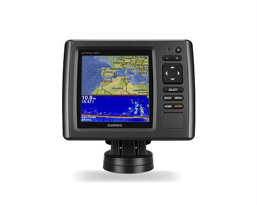
Model: 010-N1384-00- High-contrast color display with keypad control with preloaded U.S. BlueChart® g2 maps
- Built-in DownVü scanning sonar with the clearest images on the water
- Built-in 500 W (RMS) HD-ID™ sonar (4,000 W peak-to-peak)
- 5 Hz Internal GPS updates position and heading 5 times per second
- Tilt/swivel quick-disconnect mount
echoMAP 54dv includes a 5-inch high-contrast color display with automatic backlight adjustment. Fast, responsive 5 Hz GPS/GLONASS refreshes your position and heading 5 times each second to make your movement on the screen more fluid. It also supports Minn Kota® and MotorGuide® trolling motors with integrated transducers. The combo's cords plug directly into the mount, allowing you to quickly install and remove your device from power and the mount.
Clearest Scanning Sonar on the WaterGarmin DownVü™ scanning sonar gives you a nearly photographic image down to 750-feet below your boat. You clearly see structure, submerged objects and fish! Traditional Garmin HD-ID sonar and DownVü scanning sonar are combined into one transducer. Also provides HD-ID support for Minn Kota and MotorGuide trolling motors with integrated transducers. The echoMAP 54dv also includes sonar-recording capability that coordinates the timing of the sonar return with your boat's position and saves digital information for playback on a computer using free HomePort™ planning software. Use the User Data Sharing Cable to share waypoints and routes between multiple devices.
Preloaded BlueChart g2 mapsCovers the coastal U.S. and Bahamas — East Coast, West Coast, Gulf of Mexico, U.S. side of the Great Lakes. Includes all U.S. Charts for the entire coastline and the Bahamas. Includes everything available on NOAA charts. In addition to the basic charts, tidal stations, currents, depth contours, IALA symbols and included fishing charts, BlueChart g2 offers smooth transitioning between zoom levels and more seamless continuity across chart boundaries. You can customize your screens with Safety Shading which allows you to contour shade for all depth contours shallower than what you determine is your safe depth. Fishing charts emphasize bathymetric contours with less visual clutter on the display. And there’s also a choice of standard 2-D direct overhead or 3-D "over-the-bow" map views for easier chart reading and orientation.
Heading and Position Refreshed 5 Times per SecondFast, responsive 5 Hz GPS/GLONASS refreshes your position and heading 5 times each second to make your movement on the screen more fluid. It makes dropping up to 5,000 accurate waypoints and finding your way back to your secret fishing hot spots quick and easy.
Take Your echoMAP with YouWhen you’re off the water, it’s easy to keep your echoMAP safe and secure. You don’t have to mess with plugging and unplugging wires from the unit because the cords plug directly into the mount. This allows you to quickly install and remove your echoMAP from power and the mount.
Upgrade with the Best Garmin Maps on the WaterA single microSD™ card slot provides expandable memory for accessory map purchases such as LakeVü™ HD, LakeVü HD Ultra or BlueChart g2 Vision. LakeVü HD Ultra and BlueChart g2 Vision provide exclusive Garmin Auto Guidance that directs you right to your hot spots by instantly creating an on-screen path based on your boat’s specifications that you can follow to avoid shallow water and other charted obstructions.
Applies to versions with transducers only. No transducer versions support 50/200 kHz, 77/200 kHz and Garmin DownVü/SideVü transducers, sold separately. See transducer selection guide for complete list of compatible transducers.
Specifications| Physical and Perfomance | |
| Dimensions | 5.9"" x 6.1"" x 2.4"" (15.0 x 15.5 x 6.1 cm) |
| Display Size | 3.54"" x 3.54""; 5.0"" diagonal |
| Display Resolution | 480 x 480 |
| Display Type | WQVGA |
| Weight | 1.6lbs |
| Water Rating | IPX7 |
| Receiver | 5hz |
| Antenna | Internal only |
| Mounting options | Bail or flush |
| Voltage | 10-20Vdc |
| Power consumption | 7.1w |
| Maps and Memory | |
| Preloaded maps | BlueChart® g2 (coastal maps) |
| Accepts data card | 1 microSD™ card |
| Waypoints | 3,000 |
| Routes | 100 |
| Track log | 20,000 points, 50 saved tracks |
| Features and Benefits | |
| Garmin Radar compatible | No |
| garmin Sonar compatible | Yes |
| NMEA 2000® compatible | No |
| NMEA 0183 Compatible | Yes |
| Garmin SmartMode compatible (customizable monitor presets) | No |
| Supports AIS (tracks target ships position) | Yes |
| Supports DSC (displays position data from DSC-capable VHF radio) | Yes |
| Tide tables | Yes |
| Garmin Meteor Audio System compatible | No |
| Supports Fusion-Link compatible marine radios | No |
| GSD™ Black Box sonar support | No |
| GCV™ Black Box sonar support | No |
| SiriusXM™ Weather & Radio compatible | No |
| BlueChart® Mobile (planning) compatible | No |
| Garmin Helm compatible | No |
| GRID™ (Garmin Remote Input Device) compatible | No |
| Wireless remote compatible | No |
| Wireless mouse compatible | No |
| Sonar features and Specifications | |
| Dual-frequency (50/200 kHz) sonar capable | Yes |
| Dual-beam (77/200 kHz) sonar capable | Yes |
| Transmit power | 500 W (RMS) / 4,000 W (peak to peak) |
| CHIRP sonar technology | Yes |
| DownVü™ | Yes (built-in) |
| SideVü™ | No |
| Maximum Depth | 2,300 ft @ 77 kHz, freshwater 1,100 ft @ 77 kHz, saltwater (depth capacity is dependent on water bottom type and other water conditions) |
| Bottom lock (shows return from the bottom up) | Yes |
| Water temperature log and graph | Yes |
| Sonar recording | Yes |
| Sonar history rewind | Yes |
| Connections | |
| NMEA 0183 Input ports | 1 |
| NEMA 0183 output ports | 1 |
| Video input ports | None |
| Video output ports | None |
| Wireless connectivity | No |
| Garmin Marine Network™ ports | None |
What's in the Box:
- echoMAP 54dv with U.S. BlueChart® g2 Remanufactured
- Power/data cable
- Quick-release mount
- Flush mount
- Protective cover
- Harware
- Documentation